

Getting to q̓at̓ᶿaymɩxʷ
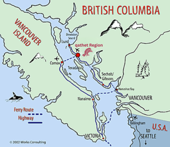
qathet Region and the City of Powell River are located at the top of the Sunshine Coast of the British Columbia mainland 135 km (88 miles) north of Vancouver. To the west lie Georgia Strait and Courtenay/Comox on Vancouver Island.
 |
By Car
From Vancouver
Enjoy a pleasant, scenic drive up the Sunshine Coast! From downtown Vancouver to Powell River will take about five hours, including two ferry rides and a short drive in between.
First, take a BC Ferry from Horseshoe Bay to Langdale, then drive north 80 km along the Sunshine Coast highway through Gibsons and Sechelt. A second BC Ferry from Earls Cove to Saltery Bay takes you into the qathet Region. Each ferry sailing lasts about 45-50 minutes.
BC Ferries
From Vancouver Island
If you are arriving from Vancouver Island, take the ferry from Little River in Comox (near Courtenay). Passage is an enjoyable 75 minutes and docks in the heart of the City of Powell River.
BC Ferries
By Air
From Vancouver
Pacific Coastal Airlines offers multiple daily direct flights from the South Terminal of Vancouver International Airport to the Powell River Airport (YPW). Flight time approximately 25 minutes between the South Terminal at Vancouver International Airport and Powell River Municipal Airport (right in town).
Harbour Air: Fly directly between Powell River and both downtown Vancouver and Vancouver International Airport (YVR South - River) with scheduled service flights twice daily landing on the stunning Powell Lake.
From Vancouver Island
WestJet has a service to Comox on Vancouver Island and is just a short ferry ride away.
Toll Free: 1-888-WESTJET (1-888-937-8538) or 1-800-538-5696